|
|
Post by dannyp on Nov 6, 2007 2:54:39 GMT -1
With stuff really starting to show up and ramps that are getting unusable, I thought it would be a good idea and perhaps keep someone from tearing up a lower unit or hull, that when we see something we could post it here to let others know,.
I would keep it to location and object.
Bethany Bridge- Rocks and stumps close to the eastern most no wake buoys south side
|
|
Ron288
Executive Member
Posts: 2,148
|
Post by Ron288 on Nov 6, 2007 3:28:28 GMT -1
sounds good to me
|
|
|
|
Post by starvin on Nov 6, 2007 10:47:06 GMT -1
Great Idea. Maybe it will save some of us some money and tears.
|
|
|
|
Post by tr21x05 on Nov 6, 2007 13:20:50 GMT -1
Yes great idea. I just got back from West Point lake fishing the Georgia State Championship and there are stumps showing up everywhere. Even down by the dam between the channel markers there are stumps. I got lucky and never hit anything. I'll be out on Allatoona soon and if I see anything I will post it.
|
|
twmooney
Executive Member
Rather be fishing . . .
Posts: 627
|
Post by twmooney on Nov 6, 2007 13:44:57 GMT -1
Cove just north of the Dam there are a reef marker on the right hand side. At first it doesn't appear that it stretches from the bank because of the distance but it really does. Stay to the left and do not pass between the marker and the bank.
Sure some of you know but I didn't but luckly I was was trollin an fishing. Never hit anything but good lord at the stumps and boulders!
-Terry
|
|
|
|
Post by tgragg on Nov 6, 2007 20:40:46 GMT -1
Great idea, I was in the Pass down below Bethany on Sunday and was motoring around taking pictures and was on the left hand side on the back side of the flat that is out of the water in 12'. Put it in gear and it was to late chewed the prop all up on another flat that was just below the water. I never seen it, the good thing about it, is I have a new coordinates on the finder.
|
|
|
|
Post by ranger481vs on Nov 6, 2007 20:53:00 GMT -1
Be careful between Allatoona Landing and the couple of long points coming out on your right if you are coming form the blockhouse. I hit a tree in 20ft of water. The tree top had to be near the surface as my speedo in my motor was clogged with wood after I got it on the trailer. Luckily still have my lower unit and everything works fine, but could have been a bad day!
|
|
|
|
Post by soretoe on Nov 9, 2007 22:42:28 GMT -1
Be careful between Allatoona Landing and the couple of long points coming out on your right if you are coming form the blockhouse. I hit a tree in 20ft of water. The tree top had to be near the surface as my speedo in my motor was clogged with wood after I got it on the trailer. Luckily still have my lower unit and everything works fine, but could have been a bad day! That is about where I wrecked last week.  |
|
|
|
Post by Mike Bucca on Nov 10, 2007 5:45:35 GMT -1
Iron hill right now is down right dangerous!! Somebody is going to lose a boat and/or a lower unit there. There is a long point/hump out in the very middle of that big wide bay just inches under the water. I think this is the same one Z21mtg is speaking of. Here are a few of the bad spots in the vicinity of the dam. That one at Iron hill is a beast!! Yes I hit it!! LOL. 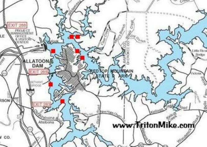 |
|
|
|
Post by euharleeriverrat on Nov 11, 2007 22:20:03 GMT -1
If this keeps up, there's going to be less riding and more jumping out and pulling the boat. Thanks for the info. ;D
|
|
|
|
Post by acebarker on Nov 12, 2007 19:57:30 GMT -1
If Iron Hill is that southern most mark on that map then I hit it Sunday. Came out of nowhere.
|
|
|
|
Post by Mike Bucca on Nov 12, 2007 20:02:05 GMT -1
Chris, That be it LOL. BAM!!
Mike
|
|